Designing maps can be a complex process, made more complex if there are lots of changes during the project.
We’ve written this simple guide about what to consider when commissioning a map design to make the process quicker, smoother and to keep costs in check.
- Consider your audience and how they will use the map.
- Decide on scale and orientation.
- Check you are able to use any data (you can’t just redraw an OS map.
- Choose your medium carefully – graphic or watercolour, for example.
- Use design to serve the user: do not overdesign.
- Don’t forget clear and intuitive labelling.
- Does it need to be interactive? Not everyone likes overly complex interactivity when a static image suffices.
- Consider your users – design for accessibility and legibility.
- Agree on the brief and revisions with the designer up-front.
- Check for ownership and licences – if you’ve commissioned an illustration, you may not own the full rights.
You’re not buying a pretty picture. You’re buying clear information that people can trust and act on.
If you get the brief right and let the pro do their job, you’ll avoid the endless “can it just… pop?” spiral.
1. Goal and audience first
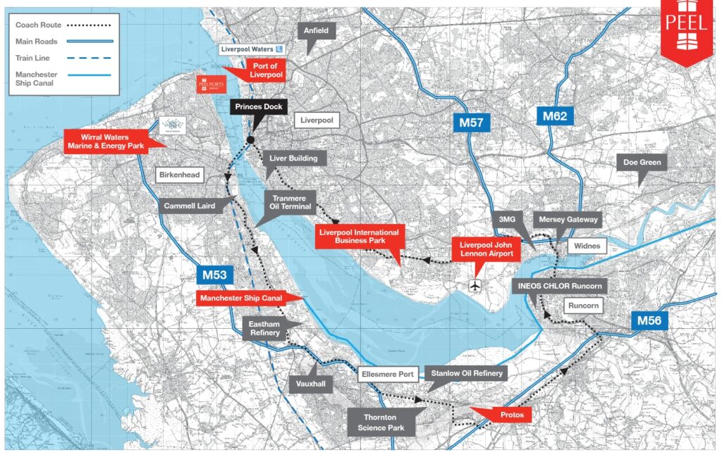
Decide the single job your map must do and who needs it. What is the purpose of the final illustration>Routing? Showing sales regions? Visitor wayfinding?
Write that down in one line.
Then list the actions you want after someone reads it. Strategy first, design second. Same energy as writing website copy before the layout: content leads; design follows.
Ask your designer: “What would you remove if the map had to do just one thing?”
This is often a key part of map design – it’s easy to get too creative and lose sight of the entire point of the map in the first place.
Too many creative ideas can take all the life out of a map: you want to create one that details what the viewer needs to see, not fill it with overly detailed information that’s not really needed to show locations or allow viewers to determine where they need to go.
2. Area, scale and projection
Define the exact extent (bbox), the scale(s), and whether the map is print-only, screen-only, or both. Agree a projection that suits the job (equal-area for stats, conformal for navigation, etc.). Note any scale thresholds for symbol changes and generalisation. Vagueness here = clutter later.
Ask: “Which projection and why? Where will scale changes kick in?”
3. Data sources, freshness and licensing
List every dataset, its date, and who owns it. Confirm update cycles and legal terms (OS, OSM, commercial, in-house). If you don’t check licences up front, you can ship a lovely map you’re not allowed to use. Do due diligence; don’t take vendor claims at face value.
Ask: “Show me source, licence, and last-updated for each layer.”
4. Medium and output specs
Print needs size, scale, DPI, colour mode (CMYK/spot), bleed, and paper. Screens need pixel sizes, DPR/retina assets, and performance budgets. Signage needs viewing distance and contrast. Lock the technicals. This prevents rework later.
You should also consider making sure your map is on-brand. Are watercolour illustrations suitable, or is a more bespoke illustration in a graphic style more appropriate?
Just like any commissioned artwork, it’s important to get the medium sorted from the start, as creating a new map if you change your mind can be costly.
Ask: “What are the master deliverables? Print-ready PDF? SVG? GeoJSON? Tiles?”
5. Style that serves the message (not an ego)
Brand colours and nice type are fine, but legibility wins. Keep it clean. The first job of design is to be appropriate, not to perform tricks.
If you push for three wildly different “concepts,” you’ll get one solid option and two fillers. Choose clarity, not theatre.
A map design project, especially if you are planning to use watercolour illustrations, can take a lot of time to produce.
Also, colour palettes need to be carefully considered – are you going to use brand colours, or is going off-brand more appropriate for what the finished piece needs to convey?
A key thing to also remember is that you should approach an agency that creates (or can art direct the creation of) the style of map that you need.
An agency may often need to commission illustrations as part of the project, which can add both time and cost.
Ask: “How will the style reinforce hierarchy and readability?”
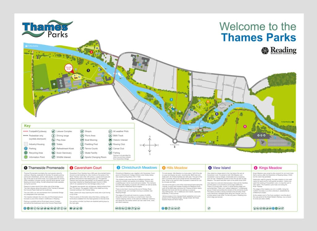
6. Labelling and hierarchy
Names make or break maps.
Set rules for priority, language/romanisation, abbreviations, leader lines, halos, and collisions.
Define visual hierarchy across base, features, labels, and overlays so eyes land in the right place, in the right order.
Ask: “What’s the labelling spec and conflict strategy at each scale?”
7. Static vs interactive (and performance)
For web maps, agree the stack (vector tiles, raster tiles, or static SVG), hosting, analytics, and speed targets.
Avoid “colouring in a template” if the map has serious work to do – heavy, one-size-fits-all tools load the kitchen sink and then some. Keep it lean and purposeful.
Apps like Maplic might provide the answer to what you are looking for if you want a complete interactive map for your website – we can help you with this.
Ask: “What loads on first paint? What’s deferred? Show me a lighthouse-style budget.”
8. Accessibility and colour use
Design for colour-blind users, low vision, and poor light. Use tested palettes, real contrast, and patterns/textures – not just colour.
Ensure keyboard access and sensible focus for interactive maps. This helps users and dodges legal grief.
Clarity beats clever every time.
Ask: “How is this map accessible without colour alone?”

9. Process, feedback and revisions
Agree milestones: discovery, draft layers, wireframe/roughs, first full pass, amends, final.
Cap revision rounds and require actionable feedback (“make river 10% darker” beats “don’t like it”).
Don’t be that client who butchers a good design because Bob from Accounts had a feeling.
Ask: “How many rounds, what’s in-scope, and what counts as a change of brief?”
10. Ownership, handover and updates
You should receive the working files, export presets, symbol sets, and a short style guide for web: tiles, sources, style JSON, and deployment notes. Confirm what you own, what is licensed, and how updates will work. When you pay, it should be yours to run, not rented forever.
If an illustrator has provided illustrations, there may be additional licensing considerations – especially if you are planning to sell the file or final illustration.
Ask: “After sign-off, do we own the source and can another pro pick it up easily?”
Quick brief template to get you started
- Goal: one-line job of the map
- Audience & use: who, where, device/print
- Area & scales: bbox, zoom levels, projection
- Data: list, dates, licences, owners
- Style: brand inputs + legibility rules
- Labels: language, priority, collision rules
- Output: formats, sizes, DPI/colour, hosting
- Accessibility: contrast, palettes, keyboard plan
- Process: milestones, rounds, turnaround
- Handover: files, rights, update plan
